Best sailing apps: top apps for sailors and boaters
These days there are some truly fantastic apps for sailors and boaters. From weather and tides forecast, route planners and marine traffic, to knot guides and real time language translation, we pick out 10 of the best sailing apps
*YBW is not paid by developers for our recommendations. If you click through and buy an item, we may receive a small amount of money from the retailer, at no cost to you.*
AyeTides

This popular boating app provides users with tables of daily and future tides and interactive graphs for over 12,500. It also provides information on sunrise and moon rise. It does not require a network connection.
Availability: iOS and iPad
Price: £7.99
Garmin Activecaptain

Garmin Activecaptain connects to Garmin chartplotter, charts, maps, provides unlimited access to the user’s cartography. It also connects to the ActiveCaptain community to share information on routes, marinas and much more. It allows the user to create routes, save them and transfer them between the app and chartplotter. Can upload and download the latest Garmin Quickdraw Contours content from the community.
Availability: Android and iOS.
Price: Free, in-app purchases apply.
Navionics

A superb and popular sailing and cruising app. Users can access nautical charts with tides and currents, informations on marinas and ports, see and create Sonar charts, share information with other users, locate fishing areas and more.
Availability: Android and iOS.
Price: Free, annual fees and subscription depending on location applies (UK, Ireland and Holland £32.99).
Knot Guide

Easy to follow knot guide with step-by-step guide and instructions and plenty of knot types to choose from.
Availability: iOS and Android.
Price: Free
GRIBView by Theyr

High resolution weather forecast built on precise data from 10km down to 1km resolution on an hourly time step. Free global forecast data with overview of the oncoming weather. Can be downloaded for offline use which offer free offline charts with no need for internet connection. It was used during the 2018 Round The Island Race.
Availability: iOS, Android and iPad.
Price: Subscription $14.99 per month or $99.99 per year.
Windfinder Pro

Detailed information on wind, tides and weather forecast in over 8,000 locations around the world. Animated maps for temperature and precipitations. Topographic maps and satellite images.
Availability: Android and iOS.
Price: £7.99
Transas iSailor

Created for amateur boaters, Transas iSailor provides navigation information and electronic charts. It offers wind and tides forecast, information on marinas and routes, sailing guides and plenty more navigational features.
Availability: Android and iOS.
Price: Free, in app purchases apply.
DROTR

Not created specifically for sailing but DROTR is very useful when travelling as it translates voice calls, text messages, documents and conference calls in several languages in real time. Users can save files and download conversations.
Availability: iOS and Android.
Price: Free
Marine Traffic

Marine Traffic displays the locations of yachts and ships in quasi real time. It covers major ports and shipping routes and is connected to the largest network of AIS receivers.
Availability: iOS and Android.
Price: £4.99, in-app purchases apply.
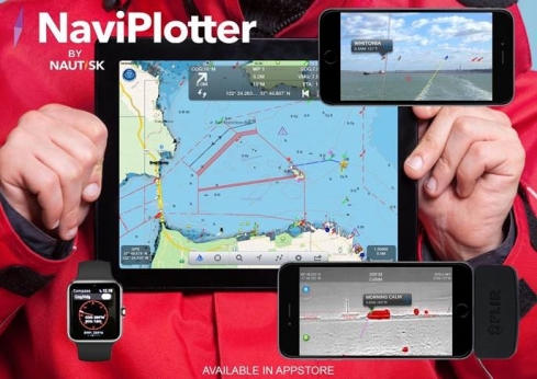
NaviPlotter

Navigational charts, trip and route planning tools, real time tracking, weather and tides forecast, moon and sun times, live AIS vessel positions, marine vector charts and more.
Availability: iOS and Apple Watch.
Price: Free, in-app purchases apply.
10 Top innovations in the history of sailing
From celestial navigation to GPS technology, these sailing innovations have changed the way we take to the sea. And we…
Boataffair launches the Boat Swapping Community
Boataffair's Boat Swapping Community allows yacht owners to swap their craft with other boaters in over 40 locations in the
OLAS – the man overboard location alert app which aims to save valuable time
OLAS converts your smart phone or tablet to become part of your life saving inventory, sounding the alarm when the…


